
Start from scratch — or from a real trail.
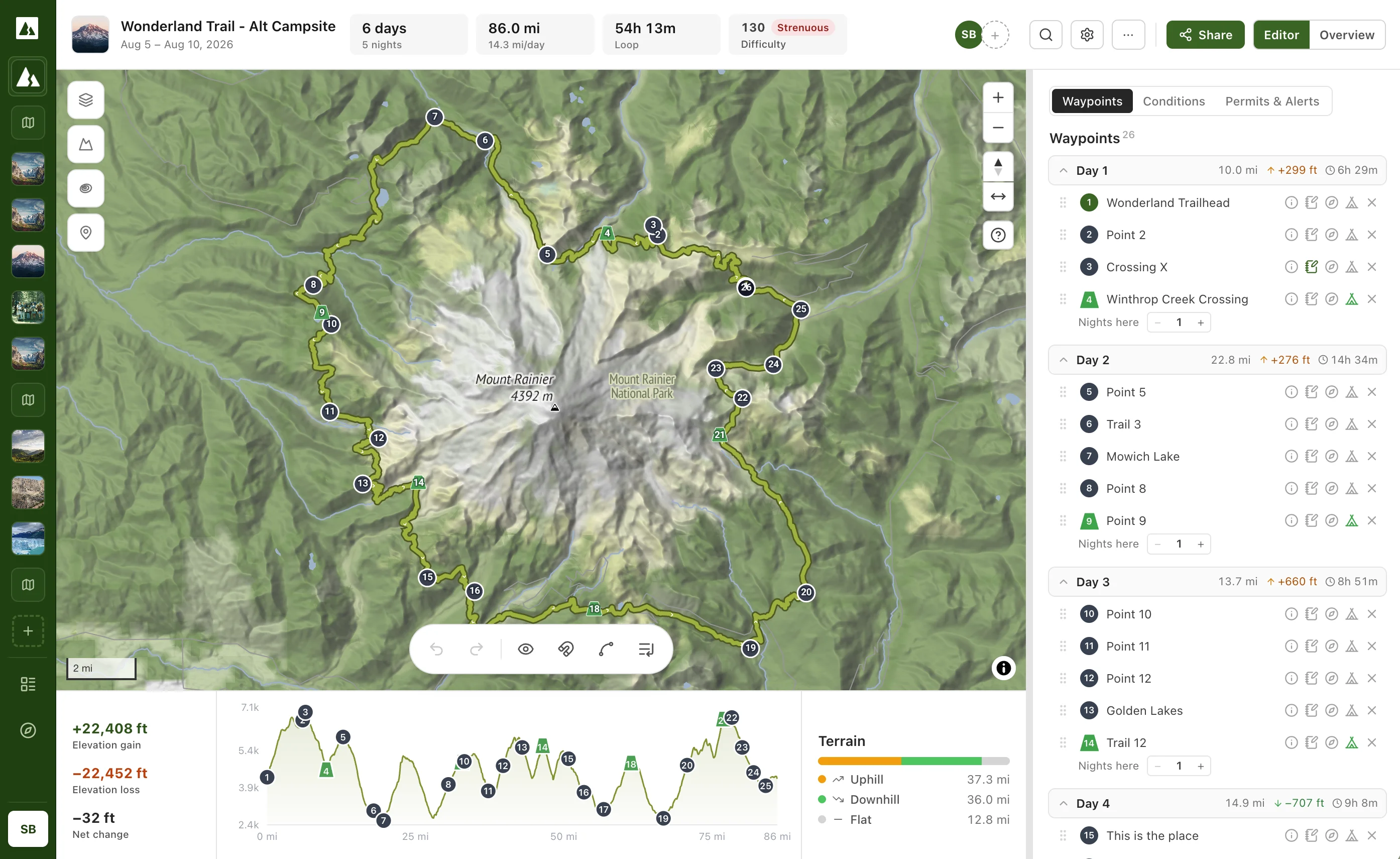
Create a free account and you're on the map in seconds. Draw your own route anywhere in the world, or skip the blank page: open one of our 569 free trail guides — the John Muir Trail, the W Trek, the Wonderland — with the route and camps already loaded. It becomes your own editable copy the moment you open it.
Draw Your Own
A blank map and the draw tool. Tap to lay down your route.
Pick a Trail & Make It Yours
569 classics, pre-routed with camps. Move a campsite, reverse it, add a side trip — it's your copy.
Tap the map. The magnet does the rest.
Every tap drops a point, and the magnet snaps the line between points onto real trails — no tracing switchbacks by hand. Heading cross-country? Toggle the magnet off and draw free. Click the line to add a stop mid-route, drag any point to move it, and undo anything with ⌘Z.
Bring your crew in. Literally.
Trips are planned in group chats and ruined in group chats. Invite your friends by email and everyone edits the same live plan — you watch their cursors move across the map as they nudge a camp or add a swimming hole. One plan, always current, no screenshots.
Tap where you'll sleep.
This is the step no other planner has. Tap any point and choose "Mark as Camp" (right-click works too). Camps aren't decorative pins — they're the joints of your trip. Each one ends a day and starts the next. Staying two nights? Add a layover.
Mark as Camp
Rename Point
Delete Point
The days compute themselves.
The instant a camp lands, your trip splits into days — per-day miles, elevation gain and loss, estimated hiking time, and a difficulty for each leg. Tomorrow looks brutal? Slide a camp down the trail and watch every day rebalance in real time.
Know the weather before you commit the dates.
Give your trip a start date and every day gets its own weather — a real forecast when you're close, and typical conditions from years of history when your trip is still months out. Planning an August start in the Sierra vs. a June one? See the difference before you book the time off.
Aug 5 – Aug 8 · typical conditions
Forecast when you're close · historical averages months out
Permits, alerts, and the boring-but-critical details.
Ridgefold looks up the wilderness your route actually crosses and pulls the official permit facilities, active alerts and closures, and nearby campgrounds — from Recreation.gov and the National Park Service, not a forum thread. Then round out the plan: party size, permit status, an emergency contact, and a "call for help if we're not back by" time for the folks staying home.
Yosemite Wilderness
Wilderness Permit — required
Reserve on Recreation.gov · quota season May–Oct
Alert · Bridge out at Register Creek
Ford required — check conditions before you go
Safety plan
Party of 3 · overdue alert Aug 9, 6:00 PM · contact: Pat
Fly it in 3D. Then go for real.
Flip to 3D and tilt the map over real terrain — see the passes you'll climb and how the camps sit in the valleys. (Other apps paywall this view. We think seeing your trip is table stakes.) When it looks right, export a GPX for your watch or GPS — and go backpacking.
Try It for Free
5 minutes from now, your trip could be planned.
Free forever: routes, camps, per-day stats, live collaboration, weather, permits, 3D terrain, GPX. You only ever pay if you want offline maps.